
Washburn Co. WIGenWeb
| WHAT'S NEW |
Cemetery
Data
Earl Cemetery - Background information The Earl Cemetery has been a landmark in this area of Wasbhurn County for many years. It is located directly south of the village of Earl on County Road E, approximately ¼ mile from the junction of State Highway 63. The original tract for the Earl Cemetery was donated by Reuben McKee, one of the early settlers to the Earl community, when his wife, Sarah, died in October 1894. Up until this time, no official burial place was to be found. Sarah's gravestone is located in the southwest corner of the original block of this cemetery, or Old Addition (OA). This cemetery was also known in its early days as "McKee Cemetery". The cemetery has grown significantly over the years and has become one of the "biggest little cemeteries" in Washburn County. The record keeping has been passed from generation to generation, with the original books still in use today. It is from these books held by the past sexton and from walking the cemetery itself by Mary Wirth, that the records within these pages have been compiled. There are many burials in this cemetery that do not have stones, therefore, some of the burial locations are unknown and have not been listed here. The names of the people buried within this cemetery have been alphbetized for easier searching, but the burial locations are also noted. Please use these locations, along with the map of the cemetery, to aid in finding the graves of those you may be seeking within this cemetery. If you are in the area and stop at the Earl Cemetery, a more detailed map showing lot numbers can be found on the west side of the sexton's building within the cemetery (shown in Block 2 below). The map below shows
the various sections, called Blocks, of the Earl Cemetery and is
provided
here as an aid in helping you to more closely pinpoint where burials
are
within this cemetery. Each block is labeled, and within each
block
are numbered lots, each lot containing six graves. Blocks are
clearly
marked by the roads within the cemetery (except for Block 4, which is
bordered
on two sides by the Old Addition [OA] ). The Vets section is a
newer
area that has been designated for burial of our veterans. These
Vets
areas have previously been known as part of the 2nd Addition (2A) and
have
continued to be labeled as such within these pages. Please note
that
Lots 153 - 182 of the 2nd Addition (2A) are empty as of this date and
are
there for future expansion.
Click on the group that contains the surnames you are looking for: 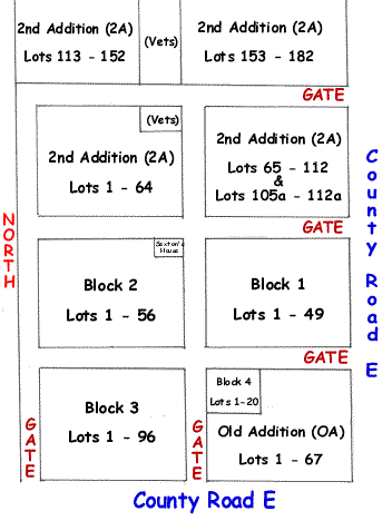 |